Taft, Florida  ·  A Local History

The Swamp They Named After the President


In 1909 two men cut sixty thousand acres of wet Orange County scrub into about three thousand little farms, sold them ten dollars down to people who had never seen the ground, and borrowed the President’s name for the town in the middle — so the whole thing would sound like a sure bet.

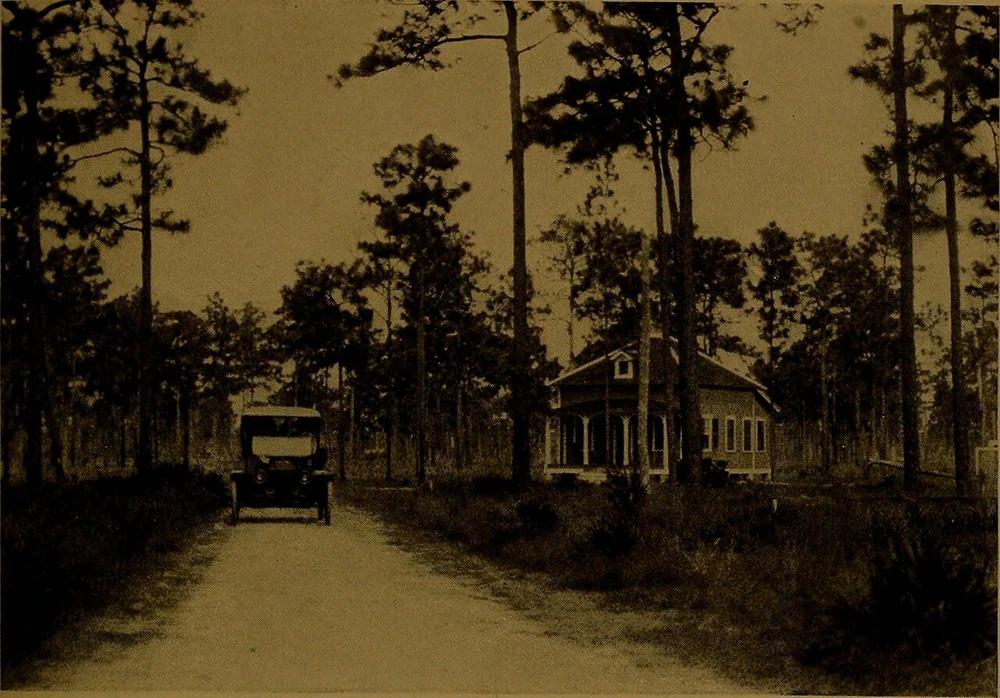
A straight sand road running back through tall pine flatwoods, an early open-top automobile parked on it and a single wood-frame house set among the trees at right.
Out past the end of the pavement — Florida flatwoods, 1914
This was the product: room. A Florida flatwoods road and a lone homestead, 1914 — the kind of country sold by the acre south of Orlando. From a Florida East Coast Railway promotional booklet, 1914; Wikimedia Commons. A representative scene of the era, not confirmed as Taft.

Ten dollars down, ten dollars a month — and in a few years, the advertisements promised, a Florida orange grove that would pay you something like ten thousand a year for the rest of your life. That was the pitch, printed up North around 1909. Thousands of people took it. Most of them bought land they had never seen, in a town that barely existed yet, named after the man who happened to be sitting in the White House.

The town was Taft, about eight miles south of Orlando. And the first real question about it is the one those buyers never got to ask from their kitchen tables up in Illinois: what was actually out there?

The far side of nothing

The answer was room. Miles of it — flat, wet, pine and palmetto, stitched together by two slow creeks. Boggy Creek ran east, Shingle Creek ran south, and all of it sat just a little above the waterline of Lake Tohopekaliga. It was the kind of country you could buy by the square mile, because almost nobody else wanted it.

A small steamboat on still, misty lake water, its reflection below it and Spanish moss hanging from trees along the near shore, printed on a vintage stereoview card.
The water came with the land
Lake Tohopekaliga, before anyone platted it. A steamboat on the lake the colony was laid out along, late 1800s. Robert N. Dennis collection of stereoscopic views, via Wikimedia Commons.

Being empty was the whole opportunity. Cheap, flat, and close enough to a railroad that you could get a crop out — if you could grow one. The land hadn’t done much for anyone yet. The trick was convincing a stranger that it was about to.

Prosper Colony

In 1909 two men decided the emptiness itself was a product. One was Braxton Beacham, who had lately been mayor of Orlando; the other was W. L. Van Duzor, down in Kissimmee. Together they took a tract of sixty thousand acres of this scrub and did something that sounds more like an internet scheme than the horse-and-buggy era: they cut it into about three thousand little farms and sold them on the installment plan.

They called the whole thing Prosper Colony. Five acres, ten acres, a town lot thrown in — pay a bit every month, and when the last payment cleared, a warranty deed came in the mail. You could walk your exact piece of ground and choose it, or you could choose it off a map from a thousand miles away. Plenty of people did the second thing.

Prosper Colony — Taft, Fla.

“$10 down and $10 a month.”

A tract of “sixty thousand acres,” midway between Kissimmee and Orlando, cut into five- and ten-acre farms with a town lot — about three thousand of them “placed on the market.” Two railroads run through it. And the colony’s own argument for the small farm: “five acres are more than enough to supply a family’s needs in this part of the state.”

— from the promoters’ notice, Kissimmee Valley Gazette, September 3, 1909

Why a swamp gets the President’s name

The land had already worn out a few names by then. A man named Newelton had settled in back in 1884 and named it after himself; then it was Big Cypress; then Smithville, after a developer who ran turpentine stills out here. None of those names sells a grove to a stranger.

A formal head-and-shoulders portrait of William Howard Taft, a heavyset man with a large mustache in a dark suit and bow tie.
The name they borrowed, 1909
The sitting President. William Howard Taft, photographed in 1909, the year he took office — and the year a colony in the Florida scrub took his name. Library of Congress, via Wikimedia Commons.

Taft did. William Howard Taft had just become President, in that very same 1909, and nothing says a place is a safe bet like borrowing the name of the man running the whole country. So the new town on the plat became Taft — even though, despite a local legend that refuses to die, the President himself never once set foot in it.

The land was cheap because it was wet and empty. The whole business was a bet that both of those things were only temporary.

Five acres and a fortune

What were you actually buying? On paper, independence. The sales talk held that five acres in this part of Florida were more than enough to feed a family, and the real money would come from citrus — set out orange trees, wait for them to bear, and let the grove pay you like a pension you never stopped collecting.

A man in a straw hat standing beside a heavily laden orange tree in a Florida grove, the fruit hand-tinted orange on an old stereoview card.
Where the money was supposed to be
The grove that was meant to pay you. A Florida orange grove of the period — the crop every colony brochure was really selling. Dennis stereoscopic views, via Wikimedia Commons.

And for a stretch it wasn’t a fairy tale. The soil really did carry rich muck and hammock in it, and the higher sandy patches really did grow oranges. A town grew up to go with the groves.

The railroad put in a depot in 1910. Taft got a mayor, a post office, electric lights, a jail, and — the detail that tells you a place believes in itself — a policeman on a motorcycle. Turpentine, lumber, and farming all ran at once, and the fruit went into crates and rode north on the Atlantic Coast Line.

Men loading wooden crates of oranges onto early flatbed trucks in front of a tall frame packing house painted with the words Oranges and a grower’s name.
Oranges, headed north
When the crop came in. A Florida citrus packing house loading fruit for shipment, 1910s. “Strawn Packing House,” via Wikimedia Commons — a representative grower of the era, not Taft itself.

The catch was the water

But the thing the brochures skipped right past was sitting there in one word: muck. Muck is what you call soil that’s half swamp. Before it grows you a pension, it has to be dry — and this land was anything but.

So the real monument of boom-time Taft isn’t the depot or the park they drew on the plat. It’s the ditch. In 1913 the town set up the Taft Drainage District — a whole little government whose only job was to dig the water back out and keep it out. Thousands of acres sold as ready-made farms turned out to need draining first, one canal at a time.

A tall steam-powered dredge sitting in a half-dug canal cut through open marsh grass, its boom and bucket silhouetted against the sky, water in the foreground.
Digging the water back out
The real work of a Florida land boom. A steam dredge cutting a drainage canal through the marsh, 1921 — the same job Taft’s Drainage District took on starting in 1913. Via Wikimedia Commons; a representative Florida dredging scene.

You kept building on the room

Here’s the part that outlasted the sales pitch. The people who actually came and stayed did the oldest Florida thing there is: they bought their ground, and then they built onto it as needs came up. A house. Then a barn. A packing shed. A pen for a few head of cattle. A second little place out back when family turned up.

You never really finished buying a farm out here. You just kept building on the room. The five acres weren’t a thing you owned so much as a thing you added to — which is exactly why so much of the colony is still legible today, long after the orange-grove math stopped working.

What the room became

Because the grove-as-pension dream mostly didn’t pan out the way the ads drew it. Freezes, drought, then the Depression — Florida collects on optimism about once a generation — and in 1933 Taft quietly gave up its town charter and went back to being a wide spot on the map.

Then the century turned the room into something nobody in 1909 could have pictured. Quiet, flat land beside two rail lines, a few miles from Orlando, turned out to be perfect for one very modern crop: warehouses. Today Taft is wrapped around Orlando International Airport, and the old colony grid is lined with loading docks — UPS, FedEx, the names on the trucks that now haul what oranges used to.

A dense grid-pattern street map of unincorporated communities south of Orlando, lakes scattered through it and a wide expressway curving across, with Taft marked among the labeled places.
What the farms turned into
The colony grid, still on the map. A grid map of the communities south of Orlando, Taft among them, with the airport and expressway cut through. Pine Castle Historical Society, via RICHES of Central Florida (UCF). Mid-20th century.

What’s still here

Look closer, though, and the colony hasn’t gone anywhere. The street grid Beacham and Van Duzor laid out is still the street grid. The creeks still run where they ran. And the lake they platted it all along is still sitting there, doing nothing in particular, the way it was before anyone tried to sell it.

A calm, wide lake under a blue sky with scattered clouds, a long wooden fishing dock reaching out over the water from a grassy shore.
The room, still here
Lake Tohopekaliga today. The same water the colony was laid out along, still open, still quiet. Photograph 2015; Wikimedia Commons.

The neighborhood that stuck it out even made a landmark out of the name — the borrowed one that was supposed to make a swamp sound safe. It’s a point of pride now, which is about the best thing that can happen to a sales gimmick.

A low concrete wall painted with a bright geometric mural spelling TAFT in bold colored letters, with the words Great Futures Start Here above it.
Taft, today
The name, worn with pride. A community mural in Taft, 2018. Orange County Government.

The oranges-as-salary never really arrived. The President never arrived at all. But the one thing the colony was genuinely selling — room, out past the edge of the city — came through completely. It’s still the whole story of this place. The only thing that’s changed is what people decide to build on it.

A present-day note · Orange Tiny Homes

The room out back is still the whole idea.

Strip away the orange-grove brochures and Taft is a plain Central-Florida story: people buying a patch of ground and then building onto it, a piece at a time, as life asked them to. A house. A barn. A packing shed. A little second place out back when family turned up. The room was never decoration — it was where the next needed thing went.

That instinct still pays. These days the thing people build out back has a name — an ADU, an accessory dwelling unit — and it’s what we do. A granny flat so a parent can live close with their own front door. A guest house. A rental out back that helps carry the mortgage. A tiny home on the far corner of the lot. The same move those colony families made, just with a kitchen, a bathroom, and a permit.

And you don’t need a ten-acre farm to do it. All across greater Orlando — the roomier lots out toward Meadow Woods, Southchase and the airport side, sure, but plenty of ordinary yards closer in too — the space is already there. What actually decides it comes down to your own address:

The real answer to “is there room out back for this?” isn’t a guess — it’s a handful of facts about your lot. That part we can check for you.

Put in your address and we’ll pull what your parcel allows and tell you whether a granny flat, guest house, rental, or tiny home actually fits — before you spend a dollar on drawings.

Start the ADU Fit Check→
Sources & Photo Credits

On the history

Where sources disagree: the Orange County account dates Taft’s incorporation and depot to 1910, while Wikipedia’s infobox lists incorporation in 1912 (and unincorporation on August 1, 1933). This page states the depot came in 1910 and the town surrendered its charter in 1933, and does not pin a single incorporation year. The “$10,000 a year” figure is given here as what the advertising promised, not as a record of actual returns. What is specific to Taft: the colony’s terms and founders (the 1909 Gazette), the naming and town history (Orange County), the surviving grid (RICHES), the modern mural (Orange County), and Lake Tohopekaliga, which the colony was laid out along. Full notes are in source-record.md beside this page.

Photographs

  1. Florida flatwoods road and homestead (hero) — a sand road through pine flatwoods with an early automobile and a lone house, 1914. From “Livestock farming in Florida along the lines of the Florida East Coast Railway” (1914), via Wikimedia Commons. A representative Florida flatwoods scene of the era, not confirmed as Taft. File: florida-flatwoods-road-1914. commons.wikimedia.org
  2. Lake Tohopekaliga, steamboat — a steamboat on the lake, late 1800s, cropped from a stereoview card. Robert N. Dennis collection of stereoscopic views (New York Public Library), via Wikimedia Commons. The genuine lake the colony fronted. File: lake-tohopekaliga-stereoview-c1890. commons.wikimedia.org
  3. President William Howard Taft — head-and-shoulders portrait, 1909. Library of Congress, via Wikimedia Commons. The town’s namesake. File: taft-president-1909. commons.wikimedia.org
  4. Florida orange grove — a man beside a laden orange tree, period hand-colored stereoview, one frame. Dennis stereoscopic views, via Wikimedia Commons. A representative Florida grove of the era. File: florida-orange-grove-period. commons.wikimedia.org
  5. Citrus packing house — crews loading crated oranges onto trucks, 1910s. “Strawn Packing House,” via Wikimedia Commons. A representative Florida grower of the era, not Taft. File: florida-citrus-packing-house-1910s. commons.wikimedia.org
  6. Dredge cutting a drainage canal — a steam dredge at work in the marsh, 1921. “Dredge at work on the Tamiami Trail,” via Wikimedia Commons. A representative Florida drainage scene, standing in for the work of the Taft Drainage District. File: florida-canal-dredge-1921. commons.wikimedia.org
  7. Grid map of communities south of Orlando — the street grid including Taft, with the airport and expressway, mid-20th century. Original from the Pine Castle Historical Society; RICHES of Central Florida, University of Central Florida. Contrast raised for legibility; content unchanged. File: taft-grid-map-1960s. richesmi.cah.ucf.edu/omeka/items/show/7973
  8. Lake Tohopekaliga today — the lake with a fishing dock, 2015. Modern. Wikimedia Commons. File: lake-tohopekaliga-today. commons.wikimedia.org
  9. Taft community mural — a painted “TAFT” mural, 2018. Modern. Orange County Government. File: taft-today-2018. newsroom.ocfl.net

Original downloads and a full research record are kept alongside this page in assets/images/originals/ and source-record.md. Several images are genuine photographs of the right place and era used to show what the colony’s land, groves, and drainage looked like; each is labeled above as specific to Taft or representative. No historical image was altered in a way that changes its content; the two stereoviews were cropped to a single frame. The Polaroid frames and handwritten notes are CSS added around the images, never onto them.