Chaine Du Lac, Windermere · Orlando, Florida  ·  A Local History

The Town That Got Rich and Kept Its Dirt Roads


Behind the gates west of Orlando, the houses trade for millions. The streets out front are sand — kept that way on purpose. To understand why, you have to go back to a frontier that paid people in land to spread out and build. The whole place was bet on one thing: room.

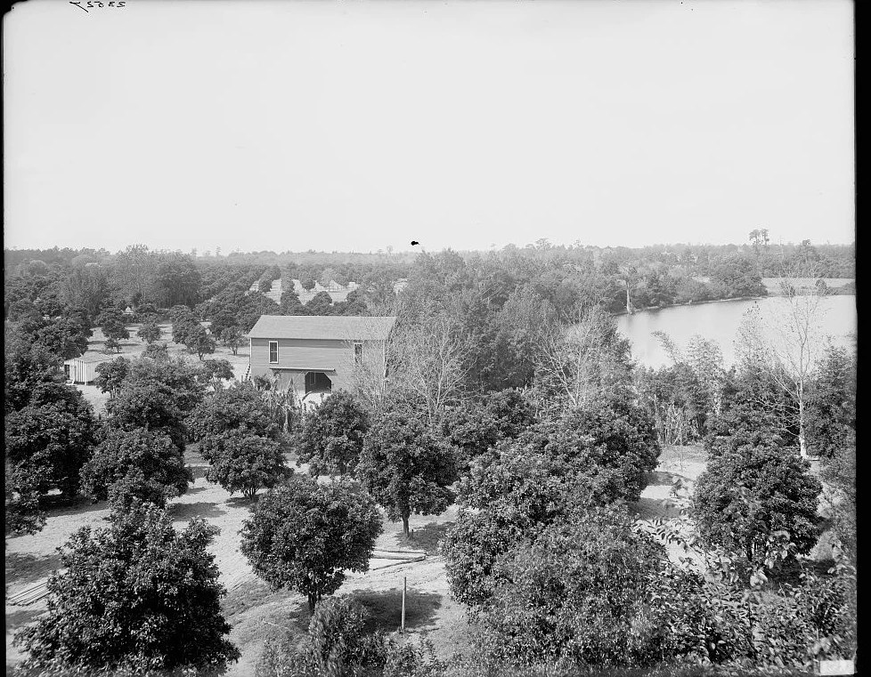
An elevated view across rows of orange trees running down to a lake near Orlando, a packing shed among the trees, more groves to the horizon.
Groves down to the water, near Orlando — about 1900
The whole idea, in one frame. Orange groves running down to a lake near Orlando around 1900 — room on the water, which is what this corner of Florida was always selling. Detroit Publishing Co., Library of Congress. A representative Central Florida grove-on-the-water of the era.

Drive out to Windermere, just west of Orlando, and the first thing that doesn’t add up is the roads. The houses behind the gates out here sell for millions. The streets in front of them are dirt. Not a few forgotten lanes nobody got around to — the town keeps them that way deliberately, and spends real money fixing them when the rain tries to carry them off. One of the pricier little addresses in Orange County, and it still won’t pave.

So here’s the question that pulls on you once you notice it: what is a town protecting when it protects a dirt road?

The answer doesn’t start with the town. It starts with the thing the town was built to sell — and that goes back before there was a Windermere at all, to a stretch of Florida where the one thing nobody was short on was space.

The deal was always room

Before any of this had a name, Florida’s whole pitch to an outsider was land. In 1842 the government made it official with a law aimed at filling up the empty middle of the peninsula: build a house, clear and plant five acres, keep a gun, stick it out five years — and a hundred and sixty acres were yours. The country was paying people in ground to come down here and spread out.

A hand-built Florida log house with a tall stick-and-mud chimney standing in open pine woods, two men and a child posed in the swept sand yard out front.
A Florida cracker house — 1886
Clear five acres and it’s yours. A Florida log house with a mud-and-stick chimney, photographed in 1886 — the kind of place that satisfied the bargain. “Florida — Cracker House with Mud Chimney,” Geo. Barker, Library of Congress. A representative frontier dwelling of the era.

You can see the shape of it in a cabin like that. A man dropped a house on an empty quarter-section, cleared what he could reach, and the land was his for staying put. Nobody handed you a finished place. You got the room and built the rest — a house first, then a barn when there was money for one, then a grove, then whatever else the family turned out to need, added on a piece at a time because the space was sitting right there to add onto.

Room was the one thing the frontier had plenty of — so it gave it away by the quarter-section, to anybody who’d build.The shape of the whole story

And the ground that would become Windermere was exactly the kind of place that bargain was written for — a sandy ridge threaded between a chain of clear lakes, pine and palmetto running off in every direction, with nobody much on it yet.

Pine, palmetto, and loose cattle

What lived on that land first wasn’t a grove or a town. It was cattle, mostly, drifting half-wild through the pines. Florida ran open range — no fences, no tidy pastures, just scrub cattle wandering the flatwoods and lean men on marsh ponies who went out and found them. They cracked long whips to move the herds, which is where the old nickname for a certain kind of Floridian comes from. This was cow country before it was anything else.

An illustration of a lone Florida cow hunter on a small horse in open pine country, rifle across the saddle, hat pulled low.
A cracker cowboy — 1895
Who had the run of the place first. A Florida open-range cow hunter, drawn by Frederic Remington for his 1895 magazine piece on the state’s cattlemen. An illustration, not a photograph — but drawn from life in the Florida scrub, the same year a freeze was about to change the whole region.

A place like that is all room and no polish, and for a long while that was the entire selling point. Land was cheap because there was so much of it, and you measured a man’s standing by how much ground he’d managed to put under his name. The map of Orange County from those years is really just a record of that — the whole county carved into squares, with the surname of whoever claimed each piece printed right across it.

An 1890 map of Orange County, Florida, a grid of townships and sections, lakes scattered down the western half, the surnames of landowners printed across their parcels.
Orange County, 1890 — the room, carved into names
Room, on paper. A map of Orange County from 1890 — townships and sections, the chain of lakes down the west side, and the name of whoever had claimed each piece of ground printed right on it. Fries & E. W. Smith & Co., Library of Congress.

An Englishman lays out a lake village

Then in 1887 a man named John Dawe did something a cow hunter never would have. He looked at that sandy neck of land between two of the lakes — Lake Down on one side, Lake Butler on the other — and he laid out a town. Dawe was English, and when it came time to name the place he reached back home, to the lake country up in the north of England, and called it Windermere. The streets around the little grid got English lake names to match.

What drew the first families, by the town’s own account, was “clean lakes, lush orange groves and fine timber stands.” Read that again and it’s the frontier bargain dressed up a little: water, growing room, and standing timber to build with. The design itself was room — generous lots strung along the water, space between you and the next house, the lakes doing the work a park would do in a tighter town.

A small white board-and-batten schoolhouse with a pitched tin roof and a single front door, standing today in a shaded grove of oaks.
The 1890 schoolhouse, still standing
The first thing they built together. Windermere’s original schoolhouse, put up in 1890 and used until 1916 — now preserved as the Parramore House. A present-day photograph of the surviving building. Via Wikimedia Commons (photo 2007).

It filled in slowly, the way a place does when every lot is big and the nearest city is a wagon ride off. They raised a one-room schoolhouse in 1890 — it’s still standing, the oldest thing in town — and ran school in it until 1916. When Windermere finally incorporated as a real town in 1925, there were only about a hundred and fifty people in it five years later. Nobody was in a hurry. Room doesn’t reward hurry.

And once the trees were in, the groves out here were good ones, for a plain reason: all that water. A big lake holds the day’s heat and gives it back overnight, and on a cold night that’s the few degrees that saves the fruit. Lakefront ground wasn’t just pretty — it was the safe place to plant.

Three young grove workers in broad hats posed in front of a canvas camp tent, two of them holding picking pails, a crate of supplies at their side.
Grove hands at Isleworth — 1904
Somebody worked the room. Three grove workers at the Isleworth grove, on the Butler Chain at Windermere, in 1904 — pails for picking, a camp set up right in the trees. Chase & Co.; UCF RICHES / University of Florida Chase Collection. Specific to the Windermere lakes.

Getting out to it was the hard part. Before good roads, the way you reached a Central Florida lake town was by water — a little steamer chuffing up a tea-dark river to a plank landing, everybody’s freight and mail and visitors coming off the boat at the same spot. The lakes weren’t the view from the house. They were the road to it.

A small wood-burning steamboat trailing smoke on a narrow tree-lined Central Florida river, a crowd of people gathered on the sandy landing in the foreground beneath a tall cypress.
A steamer at the landing — 1886
How you got there. A wood-burning river steamer, the Okeehumkee, working a Central Florida waterway in 1886, a crowd waiting at the landing. Library of Congress. A representative Central Florida steamboat-and-landing of the era, before the roads came.

Why the roads stayed dirt

Here’s where the dirt roads stop being a quirk and start being the whole point. As the decades ran on and the rest of Orange County paved everything in sight, Windermere mostly didn’t. Not because it couldn’t afford to — because the people who lived there liked what the sand streets protected: the quiet, the slowness, the feeling of a place with elbow room instead of a subdivision. When the town has studied paving them, residents have pushed back and the council has told staff to keep the sand. Lately Windermere has spent better than a million dollars on drainage just so two of its oldest streets can flood less and stay dirt.

That’s a strange thing to pay for, until you remember what the town is. Pave the road and you’ve quietly agreed you’re just another Orlando suburb. Keep it sand, and you’re still the lake village built on room — the one thing it ever actually sold.

The same bet, with a gate on it

Then Orlando came west. Disney opened down the road, the aerospace money arrived, and the ballplayers and the famous started buying up the lakes — and grove land on clear water near a booming city stopped being cheap in a hurry. The groves gave way to gates. Isleworth went up. Keene’s Pointe went up. And in 1994, surveyors platted a new one on a finger of land reaching out between Lake Down and Lake Butler, right off Park Avenue in the old town core. They called it Chaine Du Lac — “chain of the lake.”

About a hundred acres, a guarded entrance, and fifty-some custom houses — most of them fronting Lake Butler, with docks on a run of connected lakes you can idle across to a neighbor’s backyard. Strip the gate and the price tags off it and the bet underneath is the oldest one in town: get yourself a big piece of ground on the water, and put what you want on it. The frontier cabin and the lakefront estate are the same move, a century apart. In 2025 the little gated enclave even voted to annex itself back into Windermere — the fortune-dollar community formally rejoining the dirt-road town it had grown straight out of.

A present-day view of a calm Butler Chain lake at Windermere, tall palms and shade trees along a grassy shoreline.
The Butler Chain today, Windermere
The thing that never moved. A Butler Chain lake at Windermere today — the open water that made this neck of land worth claiming in the first place, and still does. Present-day photograph, via Wikimedia Commons.

So the dirt roads are still there, and now you know why. The thing Windermere was selling in 1887 and the thing Chaine Du Lac was selling in 1994 are the same thing, and it isn’t the pavement, and it isn’t the gate. It’s the room. Pave the road and you’d be covering over the one idea the whole town is built on.

A present-day note · Orange Tiny Homes

The room was always the point.

Take the gate off of Chaine Du Lac and what’s underneath is the oldest Central-Florida habit there is: get a piece of ground with room on it, and build the thing you need out there yourself. The homesteader did it with a house, then a barn, then a grove — added on a piece at a time, because the space was sitting right there. Nobody finished their place in one season. The room was the whole invitation.

That instinct still pays, and the thing people build out back now has a name — an ADU, an accessory dwelling unit. That’s what we do. A granny flat so a parent can live close with their own front door. A guest house. A rental out back that helps carry the mortgage. A tiny home in the far corner of the lot. The old Windermere move, basically — put what you want on the room you’ve got — just with a kitchen, a bathroom, and a permit.

And you don’t need a finger of land on the Butler Chain to do it. All across the greater Orlando area — the roomier lots out toward Windermere and Gotha, sure, but plenty of ordinary yards in Conway, Pine Hills, Azalea Park, Meadow Woods and unincorporated Orange County too — the space is already there. What actually decides it comes down to your own address:

The real answer to “is there room out back for this?” isn’t a guess — it’s a handful of facts about your lot. That part we can check for you.

Put in your address and we’ll pull what your parcel allows and tell you whether a granny flat, guest house, rental, or tiny home actually fits — before you spend a dollar on drawings.

Start the ADU Fit Check→
Sources & Photo Credits

On the history

Where sources differ or detail is thin: Chaine Du Lac’s exact acreage (~102–103 acres) and home count (~51) vary a little between real-estate profiles and are given here in round numbers. The Armed Occupation Act is used as the regional origin of Florida’s homestead habit, not as a deed history of these specific lots. The Remington image is a period illustration, not a photograph, and is labeled as such. Full notes are in source-record.md beside this page. This page is deliberately a different story from the neighboring Keene’s Pointe (a citrus man’s rise) and Isleworth (buying grove land after the freeze) features — same chain of lakes, a different thread: the town’s century-long habit of room.

Photographs & documents

  1. Orange groves down to a lake near Orlando (hero) — an elevated view of orange groves running to a lake, Orlando, Florida, circa 1900. Detroit Publishing Co., Library of Congress Prints & Photographs Division. A representative Central Florida grove-on-the-water of the era. File: grove-on-the-water-orlando-c1900. loc.gov/item/2016809289
  2. Florida cracker house with mud chimney, 1886 — a hand-built Florida log house with a stick-and-mud chimney, two men and a child in the yard. “Florida — Cracker House with Mud Chimney,” George Barker, 1886 (one frame of a stereograph). Library of Congress Prints & Photographs Division. A representative frontier dwelling. Cropped to a single frame. File: florida-cracker-house-1886. loc.gov/item/2017652728
  3. “A Cracker Cowboy,” 1895 — a Florida open-range cow hunter, drawn by Frederic Remington for “Cracker Cowboys of Florida,” Harper’s New Monthly Magazine, 1895. Via Wikimedia Commons. An illustration (not a photograph), labeled as such on the page. File: cracker-cowboy-remington-1895. commons.wikimedia.org
  4. Map of Orange County, Florida, 1890 — townships, sections, lakes, and landowners’ names, drawn by J. O. Fries and published by E. W. Smith & Co., Philadelphia, 1890. Library of Congress Geography & Map Division, via Wikimedia Commons. File: orange-county-map-1890. loc.gov/item/2012592407
  5. The 1890 Windermere Schoolhouse (Parramore House) — Windermere’s original schoolhouse, built 1890, used as a school until 1916, preserved today. A present-day photograph (2007) of the surviving building. Photo by Wikimedia user Ebyabe, CC BY 2.5. Clearly a modern image. File: windermere-1890-schoolhouse. commons.wikimedia.org/wiki/1890_Windermere_School
  6. Grove workers at Isleworth, Windermere, 1904 — three grove workers with picking pails and a camp tent at the Isleworth grove on the Butler Chain, 1904. Chase & Company; UCF RICHES of Central Florida / University of Florida Smathers Libraries, Chase Collection. Specific to the Windermere lakes. Cropped off its card mount. File: isleworth-grove-workers-1904. richesmi.cah.ucf.edu/omeka/items/show/599
  7. River steamboat Okeehumkee at a landing, 1886 — a wood-burning Central Florida river steamer working a tree-lined waterway, a crowd on the landing. Library of Congress (World Digital Library). A representative Central Florida steamboat-and-landing of the era. File: florida-lake-steamer-1886. loc.gov/item/2021669929
  8. The Butler Chain today — a present-day photograph of a Butler Chain lake at Windermere (Lake Down Park). Via Wikimedia Commons. Clearly a modern image. File: butler-chain-lake-today. commons.wikimedia.org

Original downloads and the full research record are kept alongside this page in assets/images/originals/ and source-record.md. Several images are genuine photographs of the right era and region, used to show what the frontier homestead, the open range, the groves, the lakes, and the water route looked like; each is labeled above as specific to its subject or as representative. The Remington image is an 1895 illustration, labeled as a drawing. No historical image was altered in a way that changes its content — the Barker stereograph was cropped to a single frame, the 1890 county map and the 1904 grove photo were cropped at the edges and downscaled, and the Polaroid frames and handwritten notes are CSS added around the images, never onto them.