Bithlo, Florida  ·  A Local History

The City That
Stayed a Map


In 1925 it was sold as a city — six and a half miles of paved streets, a golf course going in, lots bought by people in states that had never seen Florida. Five years later, after all of it, Bithlo had a hundred and twenty-eight people. Here’s what happened to the rest of the city, and the open land it left behind.

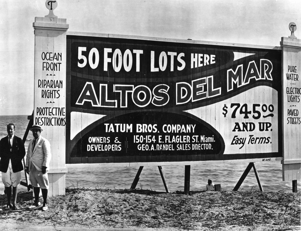
Several well-dressed men standing on open, cleared ground beside a large painted billboard advertising fifty-foot real-estate lots for sale, listing paved streets, electric lights and easy terms.
Lots for sale — before the houses
The pitch came first. All over 1920s Florida the sign went up before anything else did: cleared ground, a grid of lots, and a promise. A real-estate subdivision billboard, December 1922; World Digital Library, via Wikimedia Commons. A representative Florida land-boom scene, not Bithlo itself.

Drive east out of Orlando on Colonial Drive, past the point where the subdivisions give up and the land opens into pasture and pine and palmetto, and you come to Bithlo. It does not look like a city. But it was drawn as one — avenues laid out in a grid, numbered, a golf course on the plans, lots sold by mail to buyers who’d never set foot in Florida.

Then came the count. In 1930, after the streets were cut and the lots were sold, the census found 128 people living here. Ten years after that, 79. Ten years after that, 50.

So how does a place get drawn as a whole city, get sold to thousands of people, and then just… not become one? That’s the thing worth stopping on — because the answer is still lying right there in the ground east of town, and it explains why this corner of the county stayed open when everything toward Orlando filled in.

The railroad made a town out of nothing

Before any of it, there was a railroad and a lot of empty country. Henry Flagler’s Florida East Coast Railway pushed a branch line out through this scrub in the early 1900s, aiming south toward Lake Okeechobee, and a rail line in the backcountry is how towns got born. A siding, a post office, a name.

Tall, widely spaced longleaf pines beside a sandy road running back into the woods, with a small horse-drawn buggy far down the road.
The country the line ran through
What was out here first. Open longleaf-pine and palmetto flatwoods — the kind of land the rail branch crossed on its way south. “In the Pine Woods, Florida,” Detroit Publishing Co., 1904; Library of Congress. A representative regional scene, not Bithlo itself.

The name is the first good clue to how old the emptiness is. “Bithlo” comes from the language of the Muskogee — the people the Creek and Seminole descend from — and it means canoe. The sound in the middle doesn’t sit in English, so mapmakers spelled it with that odd “thl.” A canoe word, for a stretch of low wet pineland threaded with creeks running down toward the St. Johns. People had been poling through here long before anyone platted a thing.

The post office opened on a spring day in 1922, and that same year the place got a town charter. On paper, Bithlo was now a town. The men who meant to fill it in were already at work.

“A City with a Vision”

The developers were an Orlando eye doctor and a dentist — the kind of local businessmen the land boom turned into city-builders overnight. They’d filed a first plat back in 1919, and between 1921 and 1925 they filed it again and again, nine more times, each version bigger than the last. Every revision drew more avenues onto more acres of palmetto.

A vintage scene of early automobiles and well-dressed travelers stopped together along a Florida highway lined with trees.
The new road to the coast
And now you could drive there. On the last day of 1924, the Cheney Highway opened — Orlando’s first paved road to the Atlantic, running right past Bithlo. “Meeting Friends Along the Dixie Highway in Florida”; State Archives of Florida, via Wikimedia Commons. A representative 1920s Florida highway scene.

And the timing looked perfect. On the last day of 1924, the Cheney Highway opened — Orlando’s first paved road to the Atlantic coast, named for a local lawyer, running right through Bithlo. Now the town had the railroad and the highway. A hand-dealt pair of aces.

So they sold it hard. An advertisement in the spring of 1925 laid out the dream in full: six and a half miles of paved streets, an eighteen-hole golf course going in, and lots already bought by “more than 3,000” people scattered across the country. The slogan ran across the top in the confident way these things always did — Bithlo: A City with a Vision.

Those numbers were the promoters’ own, printed to sell lots, not a census of anything real. But that was the whole engine of the Florida boom: you weren’t buying a house, you were buying a number on a map you intended to sell to the next person for a bigger one.

Bought by mail, to sell to the next fellow

That’s the part that’s hard to picture now. Across Florida in those years, roughly two out of three real-estate deals were done by mail, by people who never came to see the land. Salesmen worked the arriving trains; a buyer could put a small deposit — a “binder” — on a lot and owe the rest in thirty days, betting the price would jump before the bill came due.

A 1920s promotional plat map of a planned Florida town, showing a dense geometric grid of streets and hundreds of numbered lots laid out across open land, with ornamental borders.
How a “city” looked on paper
A whole town, drawn before it was built. This is the plan for Aladdin City, a different 1920s Florida boom town — shown here because it’s exactly what Bithlo was: a grid of hundreds of lots sold off a drawing. “Aladdin City Florida Land Boom Map,” 1927; Wikimedia Commons. Not Bithlo, but its twin in paper.

As long as a bigger buyer was always coming, it worked, and lot prices climbed on pure momentum. The flaw is obvious the second the line of buyers stops. Then you’re left holding thousands of overpriced lots and nobody behind you to take them.

The line of buyers stopped

It stopped fast. Sales cooled through 1925. The railroads, choked with building materials, called an embargo that fall and the lot-selling machine seized up. Then in September 1926 a tremendous hurricane came ashore at Miami and tore through the state, and whatever was left of the state’s reputation as easy money went with it. The 1929 crash and the Depression finished the job.

A wood-frame house knocked off its footing and badly broken apart, with debris scattered across the sandy ground after a hurricane.
September 1926
The storm that broke the spell. The great hurricane of September 1926 wrecked much of South Florida and ended the land boom’s easy confidence. A home destroyed by the 1926 hurricane, Miami Beach; State Archives of Florida, via Wikimedia Commons. A representative scene of the storm, far from Bithlo.

About a month after that grand 1925 advertisement ran, the two developers had already sold their company to a group of investors led by a banker up in Massachusetts. Good timing for them. Terrible for whoever came next. By the mid-1930s the county record carries a short, final note beside Bithlo’s name: charter surrendered.

The town meetings petered out. The railroad branch that made the place was pulled up in the 1940s. What was left was the thing you can’t sell by mail and can’t knock down: the land, and all those streets drawn across it.

The grid stayed. The city didn’t.

Here’s the strange, quiet thing the boom left behind. The streets were real. They’d been cut and named — a couple dozen numbered avenues marching across the scrub in a tidy grid. What never showed up was the city that was supposed to stand on them.

A 1953 topographic map centered on Bithlo: the Cheney Highway and a rail grade run east-west through a small cluster at the center, while a grid of dashed, mostly empty platted streets spreads north and south across wide blank country dotted with only a handful of tiny building squares.
Bithlo, 1953 — streets, almost no houses
Thirty years on, still mostly lines. By 1953 the surveyors mapped Bithlo plainly: the Cheney Highway and the old rail grade cutting through, a platted street grid (the dashed lines) reaching out into the flatwoods — and only a scatter of little black squares where actual buildings stood. USGS 1:24,000 “Bithlo” quadrangle, 1953; U.S. Geological Survey. A detail centered on the town.

Look at how the mapmakers drew it in 1953, almost thirty years after the big sale. The highway and the old rail line run through the middle. The grid fans out north and south. And the little black squares that mean a building is here — you can count them. A city’s worth of streets with a hamlet’s worth of houses on it.

What Bithlo had, after the boom took its money and left, was the one thing the boom couldn’t carry off: room.

And people used the room the way rural Florida always has. Not as a downtown — as ground. Cattle on the open flatwoods, same as the St. Johns valley had carried since the Spanish turned the first herds loose. Groves on the higher, drier sand. A family on a few acres, a house set well back from the road, a shed, a second little place out past it for whoever needed one.

A wash drawing of flat Florida cattle range under a spreading live oak, with cattle and a mounted rider out in the open distance.
What the open land was really for
Range, not real estate. Long before and long after the boom, this flat east-county country was grazing land. Frederic Remington, “A Bit of Cow Country,” 1895, from his “Cracker Cowboys of Florida” for Harper’s. Public domain.
A small rustic log cabin with a wood-shake roof and a tall stick-and-mud chimney, a palm and pines beside it, and a figure in the doorway.
A place of your own, on your own ground
How you actually lived out here. A Florida frontier homestead of the kind raised on scattered backcountry lots — the real east-county way of using land, as opposed to the paper city. “Old Cabin at Turkey Creek,” Detroit Publishing Co., 1880; Library of Congress. A representative cracker homestead, not Bithlo.

The irony is almost too neat. Bithlo was platted tight, lot against lot, to pack a city in. What it became was the opposite: spread out, elbow room, the kind of land where you keep a little distance from the neighbors and put whatever you need in the yard. The grid was wrong about the density. It was dead right about one thing — this was a place with space in it.

Straight rows of orange trees heavy with ripe fruit running back toward a lake and a pale sky, in tinted color.
The other thing the sand grew
Groves on the dry ground. Where the sand ran high and dry, east Orange County grew citrus — the steadier money the boom never was. A Central-Florida grove heavy with fruit, “Lake Region, Florida,” Detroit Publishing Co. print, 1908; Library of Congress. A representative grove.

What’s still out there

Bithlo did eventually grow — slowly, on its own terms, nothing like the 1925 drawing. It’s still unincorporated, a working rural stretch of far-east Orange County out past the newer rooftops of Wedgefield, down the road from Christmas and over toward Chuluota. Old Cheney Highway still runs through, under a plainer name now. And the avenues are still numbered, still laid across ground that has a lot more sky over it than the men who drew them ever planned.

Stand out there and you’re looking at a city that mostly never arrived — and at the open land that outlasted it. The map wasn’t lying about the room. It was only wrong about what would fill it. A hundred years on, that question’s still open: what do you do with a big piece of east-county ground and a lot of space out back?

A present-day note · Orange Tiny Homes

The best thing on a big east-county lot is still the room out back.

Bithlo’s whole story turns on one rural-Florida habit: when you’ve got ground, you put something useful on it. The homestead families ran cattle, set out groves, and built a second little place out back for whoever needed one. The land behind the house was never just a view — it was where the next thing went.

That instinct still pays, and these days the thing people build out back has a name — an ADU, an accessory dwelling unit — and it’s what we build. A granny flat so a parent can live close with their own front door. A guest house. A rental out back that helps carry the mortgage. A tiny home on the far corner of the lot. Same idea those roomy east-county acres were settled on, just with a kitchen, a bathroom, and a permit.

And you don’t need a cattleman’s acreage to do it. Across greater Orlando — the big lots out east by Bithlo, Wedgefield, Christmas, and Chuluota, sure, but also ordinary yards in Apopka, Ocoee, Winter Garden, Conway, and Pine Hills — plenty of homes already have the space. What actually decides it comes down to your own address:

The real answer to “is there room out back for this?” isn’t a guess — it’s a handful of facts about your lot. That part we can check for you.

Put in your address and we’ll pull what your parcel allows and tell you whether a granny flat, guest house, rental, or tiny home actually fits — before you spend a dollar on drawings.

Start the ADU Fit Check→
Sources & Photo Credits

On the history

Early Bithlo survives mostly in a local-history blog, encyclopedia entries, and government records rather than a deep photographic archive of the town itself. Of the images below, only the 1953 USGS quadrangle is of Bithlo specifically; the photographs, the drawing, and the Aladdin City map are identified in their captions as representative period Florida scenes (a subdivision billboard, a highway scene, a boom-era plat map, pine woods, a hurricane-wrecked house, open range, a frontier cabin, an orange grove), not pictures of Bithlo. The advertised 1925 figures (6½ miles of streets, 3,000 buyers, the golf course) are the promoters’ own claims. Full notes are kept in source-record.md beside this page.

Photographs, a drawing & maps

  1. Subdivision real-estate billboard — a billboard advertising subdivided lots for sale on cleared Florida land; December 1922; World Digital Library, via Wikimedia Commons (public domain). Shown as the hero; a representative Florida land-boom scene, not Bithlo. File: subdivision-billboard-1922. source
  2. In the Pine Woods, Florida — open longleaf-pine flatwoods with a sandy road; Detroit Publishing Co., 1904; Library of Congress. A representative regional scene. File: florida-pine-woods-1904. loc.gov
  3. “Meeting Friends Along the Dixie Highway in Florida” — a 1920s Florida highway scene; State Archives of Florida / Florida Memory, via Wikimedia Commons (public domain). Stands in for the Cheney Highway that opened past Bithlo in 1924. File: dixie-highway-florida. source
  4. Aladdin City Florida Land Boom Map — a promotional plat map of Aladdin City, a different 1920s Florida boom town; 1927; Wikimedia Commons (public domain). Shown as a representative boom-era “paper city” plan, explicitly not Bithlo. File: paper-city-map-1927. source
  5. Home damaged by the 1926 hurricane, Miami Beach — a wood-frame house destroyed by the Great Miami Hurricane; September 23, 1926; State Archives of Florida, via Wikimedia Commons (public domain). A representative scene of the storm that broke the boom, far from Bithlo. File: miami-1926-hurricane-home. source
  6. A Bit of Cow Country — Florida open-range cattle land; Frederic Remington, 1895 (from “Cracker Cowboys of Florida,” Harper’s); public domain. File: remington-cow-country-1895. Wikimedia Commons
  7. Old Cabin at Turkey Creek — a Florida frontier log cabin; Detroit Publishing Co., 1880; Library of Congress. A representative cracker homestead, not Bithlo. File: florida-cracker-cabin-1880. loc.gov
  8. Florida orange grove (“Lake Region, Florida”) — a grove heavy with ripe fruit beside a lake; Detroit Publishing Co. print, 1908; Library of Congress. A representative Central-Florida grove. File: florida-orange-grove-1908. loc.gov
  9. USGS “Bithlo” quadrangle, 1953 (detail) — the 1:24,000 topographic map of Bithlo (field-surveyed 1952–53), cropped to the town: the Cheney Highway and former rail grade through the center, the platted street grid (dashed) spreading into the flatwoods, and only a scatter of building symbols; U.S. Geological Survey, Historical Topographic Map Collection (public domain). The one image here that is of Bithlo specifically. File: bithlo-usgs-topo-1953. source (USGS PDF)

Original downloads and a full research record are kept alongside this page in assets/images/originals/ and source-record.md. The orange-grove print and the highway scene are tinted/period images; no historical image was altered in any way that changes its content. The Polaroid frames and handwritten notes are CSS added around the images, never onto them. The 1920s map and the 1953 quadrangle are shown as cropped details.